
Can you please explain compass surveying?
Share
Get Access to:
Get Access to:
Lost your password? Please enter your email address. You will receive a link and will create a new password via email.
Please briefly explain why you feel this question should be reported.
Please briefly explain why you feel this answer should be reported.
Please briefly explain why you feel this user should be reported.

In traversing, when the compass is used for the angular measurements then it is called compass traversing or compass surveying. In this process of surveying, the compass is used to determine the direction of the survey line of the boundary work of the traverse by measuring the angles. The lines makeRead more
In traversing, when the compass is used for the angular measurements then it is called compass traversing or compass surveying.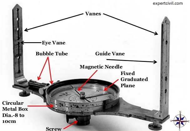
In this process of surveying, the compass is used to determine the direction of the survey line of the boundary work of the traverse by measuring the angles. The lines make angles with the magnetic meridian. The process of chaining and offsetting is similar to chain surveying and running of check line is not required.
The compass surveying is suitable under the following situation:
Also Read: Complete guide on Traverse Surveying
See lessCompass surveying is a method of surveying that uses the compass to measure angles and distances. It is a traditional surveying technique that involves taking readings with a magnetic compass to determine direction and then using other instruments, such as an odometer, to measure distances. CompassRead more
Compass surveying is a method of surveying that uses the compass to measure angles and distances. It is a traditional surveying technique that involves taking readings with a magnetic compass to determine direction and then using other instruments, such as an odometer, to measure distances. Compass surveying is often used in conjunction with other surveying techniques, such as plane table surveying, to accurately map an area.
See less