Sign Up

Continue with Facebook
Continue with Google
or use


Have an account? Sign In Now

Sign In

Get Access to:

  • Ask & get answers from experts & other users
  • Play Quiz and test your skills
  • Free Download eBooks, Notes, Templates, etc.
  • Study Materials
  • Latest Articles

Sign Up Here
Continue with Facebook
Continue with Google
or use

Forgot Password?

Don't have account, Sign Up Here

Forgot Password

Lost your password? Please enter your email address. You will receive a link and will create a new password via email.

Have an account? Sign In Now

Sorry, you do not have a permission to ask a question, You must login to ask question.

Continue with Facebook
Continue with Google
or use

Forgot Password?

Need An Account, Sign Up Here

Sorry, you do not have a permission to add a post.

Continue with Facebook
Continue with Google
or use

Forgot Password?

Need An Account, Sign Up Here

Please briefly explain why you feel this question should be reported.

Please briefly explain why you feel this answer should be reported.

Please briefly explain why you feel this user should be reported.

Expert Civil Logo Expert Civil Logo
Sign InSign Up

Expert Civil

Expert Civil Navigation

  • Articles
  • QnA
  • Spaces
  • Quizzes
Search
Ask A Question

Mobile menu

Close
Ask a Question
  • Articles
  • QnA
  • Spaces
  • Quizzes
  • Home
  • Resources
    • PDF
    • Spreadsheet
    • Template
    • Project Report
    • Question Paper
    • Presentation
    • Notes
    • House Plan
  • Subjects
    • Estimation
    • Surveying
    • Building Const.
    • Foundation
    • Irrigation
    • Geotechnical
    • Fluid Mechanics
  • Software
    • Autocad
    • 3Ds Max
    • Staad Pro
  • Marketplace
  • EC App
Home| Questions|Q 52936
Next
Answered
Oliva Jones
Oliva Jones
Asked: December 26, 20212021-12-26T19:45:07+05:30 2021-12-26T19:45:07+05:30In: Surveying

What is reciprocal levelling in surveying?

  • 5
  • 1 1 Answer
  • 27 Views
  • 4 Followers
Answer
Share
  • Facebook

    Related Questions

    • For what purpose is distomat used?
    • what is intermediate sight in surveying?
    • What is level line in surveying?
    • How to take change point in surveying?
    • What is contour line in surveying?

    1 Answer

    • Voted
    • Recent
    • Oldest
    • Random
    1. Best Answer
      Neha Kumari Beginner
      2022-01-05T20:40:33+05:30Added an answer on January 5, 2022 at 8:40 pm

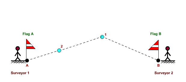
      Reciprocal levelling is the type of surveying technique or process which is done from both sides to reduce the errors. This process is done when the distance between the two points is too far. Due to the earth curvature, refraction sight can cause errors at far distance as compared to the far distance.

      Reciprocal-or-Indirect-Ranging
      Read complete article on Ranging Rod

      • 1
      • Share
        Share
        • Share on Facebook
        • Share on Twitter
        • Share on LinkedIn
        • Share on WhatsApp

    You must login to add an answer.

    Continue with Facebook
    Continue with Google
    or use

    Forgot Password?

    Need An Account, Sign Up Here

    Sidebar

    Advertisement

    Subscribe

    Recent Posts

    • Editorial Staff

      Why Does Engineering Matter in Everyday Life?

    • Editorial Staff

      Difference between architecture drawing and engineering drawing

    • Editorial Staff

      Difference Between Mortar and Grout | Different Types of Mortar and Grout

    • Editorial Staff

      Different Types of Windows for Home with Pros and Cons

    • asokchaithanya

      Procedure of Rock Salt Finish Concrete Surface

    Advertisement

    Recent Questions

    • Vipin Chauhan

      What are the causes of Dampness?

      • 0 Answers
    • Varun Kumar

      what is offset in surveying?

      • 1 Answer
    • Vipin Chauhan

      Different types of test on cement

      • 0 Answers
    • Varun Kumar

      What is chain line in surveying?

      • 1 Answer
    • Shahi

      Would you please find me a university?

      • 1 Answer

    Explore

    • Home
    • Resources
      • PDF
      • Spreadsheet
      • Template
      • Project Report
      • Question Paper
      • Presentation
      • Notes
      • House Plan
    • Subjects
      • Estimation
      • Surveying
      • Building Const.
      • Foundation
      • Irrigation
      • Geotechnical
      • Fluid Mechanics
    • Software
      • Autocad
      • 3Ds Max
      • Staad Pro
    • Marketplace
    • EC App

    Footer

    • About Us
    • Contact Us
    • Privacy Policy
    • Write for Us
    • Add Post
    • Badges
    • Rules
    • FAQ
    • Quizzes
    • Market
    • Articles
    • Q&A

    Install the Expert Civil app

    © 2022 Expertcivil. All Rights Reserved